Active Research project

Performance Metrics for Nature-Based Solutions: Leveraging 25 Years of USACE and Partner Remote Sensing Data

Project Information

This project uses more than 25 years of USACE and partner coastal remote sensing data to evaluate the long-term performance of nature-based solutions (NBS) implemented across the country. By integrating existing geospatial tools with cloud-based analysis, the team will develop standardized performance metrics that support design, monitoring, and adaptive management of coastal NBS across the USACE Civil Works mission.

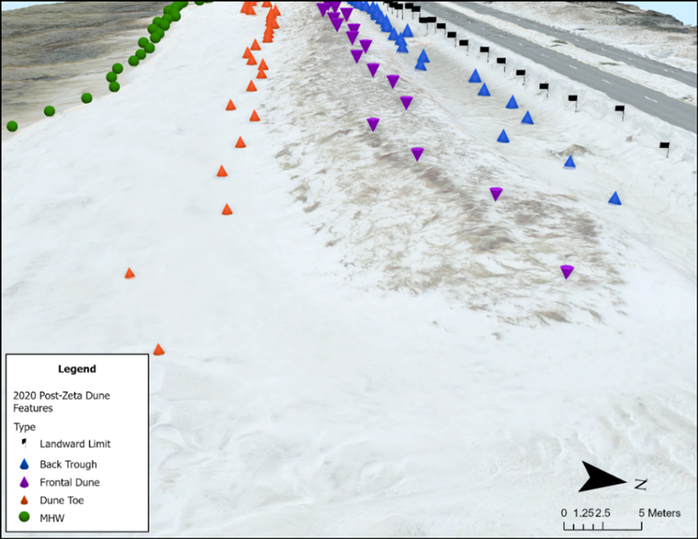
Oblique view of Long Beach, MS in Harrison County showing the locations of geomorphology features such as frontal dunes, dune toes, and back troughs (Shawler et al. In Review).

Problem

While NBS continue to gain traction across Civil Works programs, USACE lacks robust, quantitative performance metrics to evaluate their long-term success. Without these metrics, there is uncertainty about how well these features perform over time, particularly in relation to survivability, failure mechanisms, and when adaptive management is necessary.

This project responds to Statement of Need 2136 – Nature-Based Solutions Performance Metrics, which calls for the documentation and dissemination of long-term performance data for NBS projects. By filling this gap, the research supports Civil Works policy directives and strengthens evidence-based implementation of NBS.

Solution

Research Approach

  • Identify and analyze high-quality coastal NBS case studies using USACE and partner datasets
  • Engage District stakeholders to determine relevant metrics and performance concerns
  • Adapt and apply GIS toolboxes to evaluate long-term trends in feature performance
  • Migrate selected workflows to cloud environments to demonstrate scalable analysis
  • Publish data and methods in technical reports, an online hub, and open-source tools


Expected Outcomes

  • A public, web-accessible data hub showcasing case study metrics and results
  • Documented workflows for quantifying coastal NBS performance over time
  • New and modified geospatial toolkits for performance monitoring
  • Technical reports, technical notes, and a webinar for broader technology transfer
  • Support for future NBS guidance and integration into Civil Works practices

Impact

By leveraging remote sensing data already collected across the enterprise, this project will deliver cost-effective methods for assessing NBS functionality over time. The resulting metrics will guide better project design, reduce uncertainty, and support long-term sustainability of NBS in the Civil Works mission. Practitioners will gain tools and confidence to monitor, adapt, and justify the use of NBS as viable engineering solutions.

Partnerships & Collaboration

This cross-lab initiative is led by ERDC’s Coastal and Hydraulics Laboratory, with support from the Environmental Laboratory. The project team will collaborate closely with USACE Mobile District and other District partners to select and analyze case studies, ensuring products are responsive to real-world needs. Partnerships also include data coordination with NOAA, USGS, and other federal agencies.
Point of Contact

Research Forester

Research Civil Engineer

Facebook
Twitter
LinkedIn
Email

All Research

All Research Projects