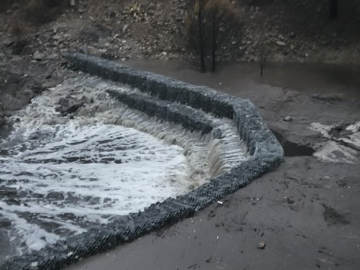
The Arid Southwest Natural and Hybrid Infrastructure (NHI) Design Workshop was held virtually on April 2, 2026, and in person in Albuquerque, New Mexico, on April 6, 2026. The workshop brought together more than 40 participants representing over 18 federal, state, tribal, academic, and nongovernmental organizations. Hosted by the U. S. Army Corps of Engineers (USACE) in collaboration with the Engineering With Nature® (EWN®) initiative, the workshop explored how natural and nature-based features could be incorporated into projects while addressing the scale, requirements and constraints typical of USACE projects. Building on the previous year’s workshop, participants examined how design processes could align with USACE authorities and requirements related to flood risk management and infrastructure protection.
Workshop Outcomes
- Identified design analysis and planned procedures necessary to implement NHI in arid environments, particularly within USACE project planning and implementation constraints.
- Prepare attendees to provide data relevant to critical uncertainties and risk concerns from existing projects.
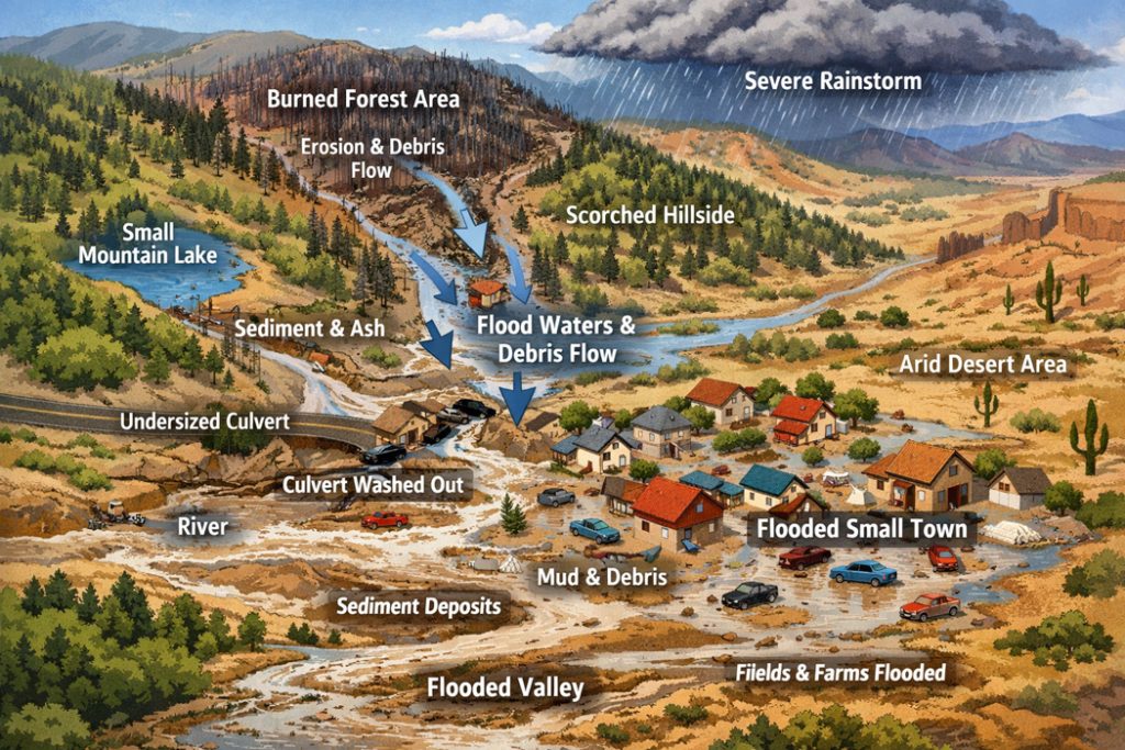
Case Study A: Post-fire Flooding (Hillslope and Tributary Scale)
This session evaluated NNBF measures to mitigate downstream flood risk, debris flows, and erosion following severe wildfires (e.g., the Foothills Fire scenario).
Challenges: Wildfire dramatically reduces soil infiltration and destroys canopy cover, triggering a “cascading effect” of high-volume runoff, rapid gully incision, water quality contamination (including fire suppressants), and risks to public infrastructure.
| Proposed NNBF Solutions and Design Considerations | ||
|---|---|---|
| NNBF Measure | Specific Application and Materials | Key Design Guidelines |
| Woody Debris Treatments | Contour felling | Must be anchored securely to prevent mobilizing into debris flows |
| Log stepdown structures | Use local, fire-killed timber to reduce material import costs | |
| Large Woody Debris (LWD) in first-order streams | ||
| Low-Tech Rock Features | One-rock dams | Well suited to certain ephemeral stream settings |
| Zuni bowls (and wood-capped Zuni bowls) | Must be keyed into the banks and bed to prevent water from bypassing or undermining the structures | |
| Media lunas | ||
| Soil and Vegetation Restoration | Mycorrhizal soil inoculation | Restores the “soil sponge” and soil organic matter |
| Seeding and mulching with native pioneer species | Native plantings must be timed with monsoon patterns to improve survival without artificial irrigation | |
Key Risks and Life Cycle Considerations
- Physical Limits: Nature-based solutions have performance limits during extreme, high-magnitude storm events. Their suitability depends on site conditions, design objectives, and anticipated flood magnitudes, with particular attention to performance and potential failure during high-intensity events. They are designed to manage frequent, low-to-medium intensity flows, not catastrophic 100-year floods.
- Sediment Management: Rock structures will rapidly trap sediment. This is a sign of success, but it requires continuous monitoring (via drones/LiDAR) and successive “lifts” (adding layers of rock over time) as the channel stabilizes.
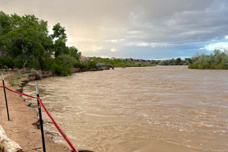
Case Study B: Riverine Erosion Around Infrastructure (Main Stem Scale)
This session focused on bank stabilization and floodplain reconnection where lateral erosion threatens critical infrastructure (such as engineered levees).
Challenges: Upstream dams control flow regimes, trapping sediment and creating a “sediment-starved” (degradational) environment downstream. This causes channel bed incision, toe erosion, and disconnection from the historic floodplain, creating a negative feedback loop that increases erosive forces.
| Proposed NNBF Solutions and Design Considerations | ||
|---|---|---|
| NNBF Measure | Specific Application and Materials | Key Design Guidelines |
| Stage 0 / Stage 8 Restoration | Strategic bank cutting | Bringing up the riverbed grade allows the river to reconnect with its floodplain, dispersing high-velocity flows across a wider, vegetated area |
| Channel filling | ||
| Bioengineered Bank Protection | Self-launching riprap toes | Combines traditional “hard” engineering at the toe with living roots that bind the upper soil bank together |
| Deep-rooted native vegetation (willow/cottonwood poles) | ||
| Low-Tech Process-Based Restoration (LTPBR) | Post-assisted log structures (PALS) | Naturally redirects erosive energy away from critical infrastructure while keeping sediment in the system |
| Beaver dam analogs (BDAs) | ||
| Bendway weirs | ||
Key Risks and Life Cycle Considerations
- The “Establishment” Gap: Unlike rigid concrete or riprap, living infrastructure takes appproximately three to five years to establish its root systems and show maximum structural strength. Temporary irrigation or watering plans may be required during the first two dry seasons.
- Contractor and Equipment Logistics: Most local contractors are only experienced in moving large rocks or pouring concrete. Playbook specifications must include simplified, highly visual construction guides. On-site “demonstration days” are highly recommended to train operators on how to build low-tech structures.
Policy, Permitting, and Regulatory Hurdles
One of the most critical discussions during the workshop revolved around the administrative bottlenecks of deploying NNBF in the Southwest:
- Water Rights and Augmentation: In the arid West, slowing down water or allowing it to infiltrate into the ground can be legally interpreted as “impounding” or “consuming” water, which conflicts with strict senior water rights downstream.
- Permitting Timelines: Post-fire environments require immediate (within weeks) action. Standard Clean Water Act Section 404 permitting timelines are slow and may not align with the short response windows needed following wildfires. Workgroups emphasized the need for pre-disaster regional general permits (RGPs) tailored for rapid-response NNBF.
- Interagency Coordination: Projects often cross U.S. Forest Service (USFS), Bureau of Land Management (BLM), state, private, and tribal lands. Creating a unified, multi-agency NEPA compliance pathway is essential.
Overarching Workshop Takeaways
- Scale Matters: Solutions must be designed at the watershed/ecotone scale rather than as isolated site-level fixes to prevent propagating problems further upstream or downstream.
- Timing and Seasonality: Construction schedules must align with local weather patterns (e.g., constructing during low-flow winter months and aligning plant propagation with the monsoon season).
- Community Co-Development: Early and continuous stakeholder engagement is crucial to align project goals with community water rights, recreational uses, and cultural values.
- Learn from Nature: Arid Southwest watersheds are highly dynamic, with hydrologic regimes influenced by snowmelt, monsoonal rainfall, and changing climate conditions. Adaptive management, long-term monitoring, and leveraging partnerships with local universities for long-term monitoring are essential to understanding and responding to these changes.
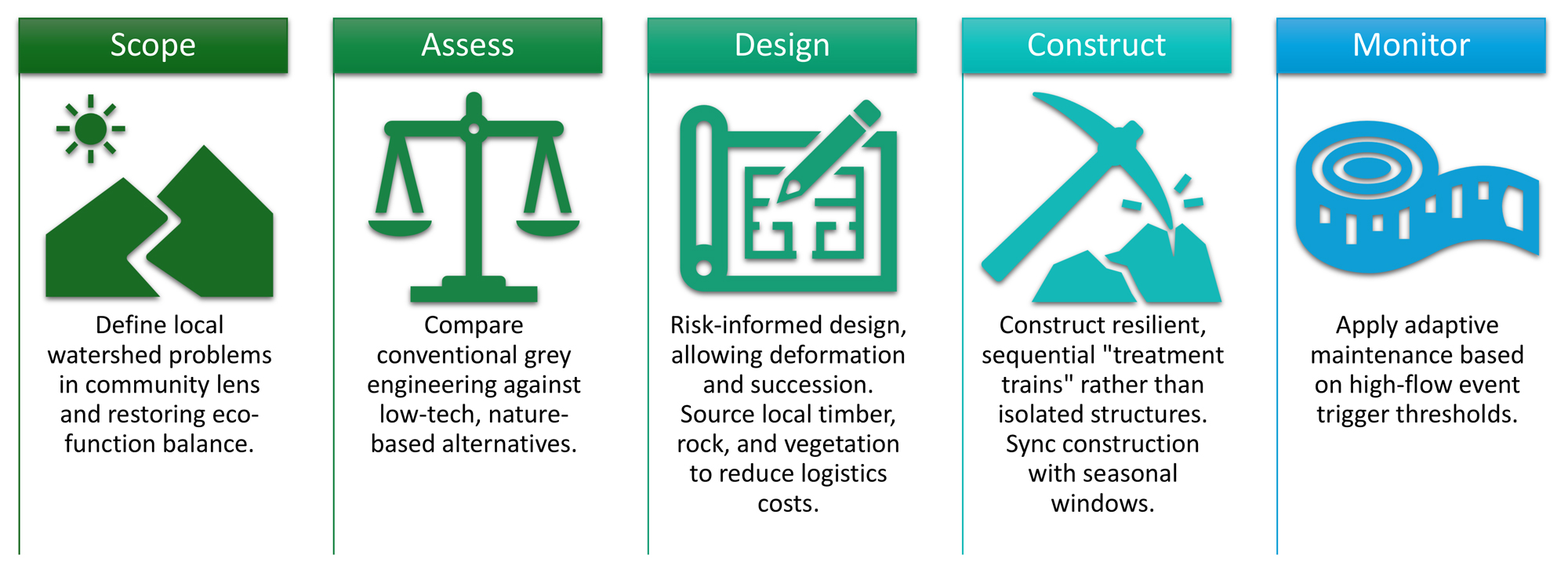
The Arid Southwest NNBF Project Lifecycle
Derived from the collaborative Miro Workspace created by the workshop participants during the virtual session.
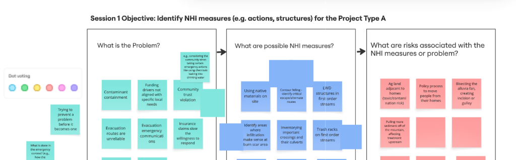
Phase 1: Scoping Phase (Problem Identification)
This initial phase establishes baseline site conditions and identifies specific ecological, structural, and socio-political issues.
- Site and Soil Analysis:
- Mapping post-burn soil characteristics, remaining vegetation status, and the depth of the hydrophobic soil layer.
- Evaluating hydraulic/hydrologic compatibility and modeling pre- and post-fire flow rates.
- Utilizing OpenET (open-access evapotranspiration data) and LiDAR to identify high-concern soil loss areas.
- Core Problems Addressed:
- Natural Risks: Post-fire debris flows, severe runoff, rapid gully down-cutting, and loss of infiltration/groundwater recharge.
- Riverine Instability: Bank erosion undercutting vegetation and channel bed degradation.
- Socio-Political Friction: Navigating jurisdictional overlaps, bridging short-term emergency responses with long-term watershed health, and resolving community concerns (such as contamination from wildfire fire-suppressant slurries in local water supplies).
Phase 2: Assessment and Evaluation Phase (Alternatives Analysis)
With site parameters defined, this phase weighs conventional engineering against low-tech, nature-based solutions to determine the best interventions.
- Soil and Slope Restoration:
- Applying mulch on burned slopes to protect hydrophobic soils from rainfall and increase water capture.
- Inoculating soils with mycorrhizal fungi to accelerate successional plant recovery and rebuild the “soil sponge.”
- Low-Tech Structural Alternatives:
- Deploying contour felling of burned logs, Post-Assisted Log Structures (PALS), wicker weirs, and Beaver Dam Analogs (BDAs) to attenuate flows in upper tributaries.
- Riverine Reconnection:
- Reconnecting channels with floodplains using grade-control structures and bank-lowering techniques (Stage 0 / Stage 8 approaches).
- Flow and Sediment Management:
- Redesigning upstream dam operations to release “environmental flows” that mimic historic high-flow spring pulses and adjust geomorphology downstream.
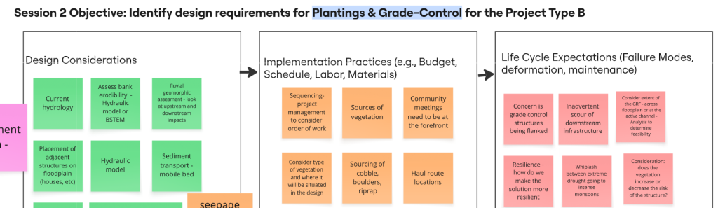
Phase 3: Feasibility-Level Analysis and Design Phase
This phase addresses structural stability, risk tolerance, and the regulatory approvals required before breaking ground.
- Design and Material Sourcing:
- Sourcing cobbles, boulders, and logs locally, including harvesting timber from fire fringes (which aids in surrounding forest thinning).
- Aligning engineering guidelines with established manuals like the USFS Rafferty Wood Design guidelines and NRCS “After the Fire” Log Erosion Barrier technical guides.
- Risk and Regulatory Hurdles:
- Regulatory Compliance: Navigating Section 404 dredge-and-fill issues, Endangered Species Act (ESA) seasonal restrictions for Threatened and Endangered (T&E) species, and the Rio Grande Compact legal flow requirements.
- Water Rights: Managing downstream water delivery schedules—slowing down water upstream must not legally violate strict senior water rights down-basin.
- Risk Aversion: Navigating institutional hesitation toward process-based NNBF designs that are intended to deform and adjust over time, compared to static grey infrastructure.
Phase 4: Implementation Phase
This stage focuses on the physical execution of NNBF, building in redundancy, and the strategic sequencing of project steps.
- Design and Implementation Mantras:
- Avoid “one-size-fits-all”: Leverage each measure’s specific ecological function (e.g., using contour felling strictly to catch soil, and BDAs to slow water).
- Accept System Dynamics: Consider tradeoffs—rigid, permanent solutions vs. letting natural processes develop a more resilient, dynamic environment.
- Build in Redundancy: Add replicates (a “treatment train”) so that if one individual low-tech structure fails or deforms during a high flow, the overall system remains intact.
- Project Timing and Sequencing:
- Low-Flow Construction Windows: Scheduling heavy in-river construction during dry winter months.
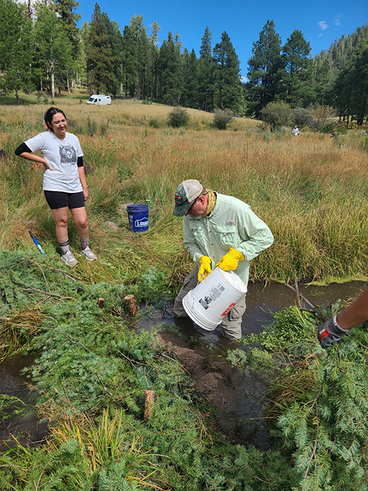
- Monsoon Synchronization: Aligning plant propagation (such as willow or cottonwood pole plantings) with early spring or right before the monsoon season to maximize survival rates.
Phase 5: Post-Implementation Phase (Monitoring and Maintenance)
Because living structures evolve, the final phase ensures the system is monitored, maintained, and adaptively managed over its lifespan.
- Monitoring Metrics:
- Tracking vegetation establishment (survival rates and percentage of canopy cover).
- Conducting post-construction compliance surveys for T&E species.
- Using frequent, low-cost drone imagery and LiDAR to track geomorphic adjustments and sediment accretion over multi-year timeframes.
- Adaptive Maintenance:
- Defining action-oriented trigger thresholds tied to event-based maintenance (e.g., inspecting and reinforcing structures after flows exceed a specific discharge rate).
- Accepting self-maintaining options: allowing natural processes to support long-term recovery, and recognizing that NNBF is designed to be shaped by natural river processes over time.
Interactive Miro Workspace
Explore the complete, unedited, collaborative brainstorm board used by the workshop facilitators and participants to map out the Arid Southwest NNBF Project Lifecycle.
Explore the Master Project Lifecycle Miro Board ↗
(Note: May require a Miro account or organizational partner login to view).
Record of Compilation and Technical Review
- Compilation System: Compiled utilizing the Department of War (DoW) Gemini Enterprise system, operating within a secure Impact Level 5 (IL5) environment.
- Source Material: Synthesized from the official Arid Southwest NNBF virtual and in-person workshop notes, facilitator summaries, and the collaborative project lifecycle Miro board frames.
- Technical Review and Approval: Reviewed for technical accuracy, programmatic alignment, and final web publication readiness by the Principal Investigator (PI), Aubrey Harris, USACE ERDC.
This may be cited as:
Harris, A. E. (Ed.). (2026). Natural and Nature-based Features Playbook for the Arid Southwest: 2026 Design Workshop Outcomes (Contributions by R. Sedeno, R. Riley, J. AuBuchon, J. Vendrzyk, B. Nash, A. Flammang and S. Bailey). U.S. Army Engineer Research and Development Center, Engineering With Nature Program. [website link]