By Paula Whitfield & Leanne Poussard, NOAA National Centers for Coastal Ocean Science
Background
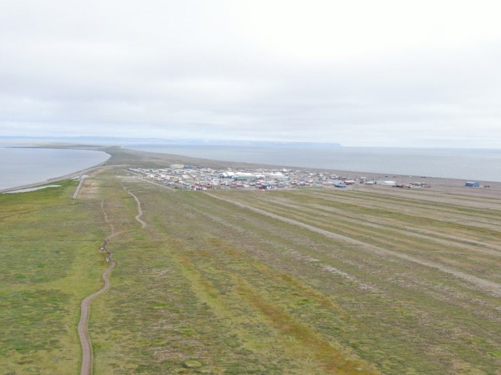
Jutting into the heart of the Chukchi Sea, 125 miles north of the Arctic Circle on the northwest coast of Alaska, is a gravel spit that is the site of one of the longest continuously inhabited village in the Americas. Twenty-five hundred years ago, the native Iñupiat (singular: Iñupiaq) settled here and founded the community of Point Hope, home to approximately 700 people. It is one of eight villages within the North Slope Borough. Today, annual erosion rates greater than three feet per year in some areas, thawing permafrost, and sea-level rise are threatening Point Hope’s unique cultural heritage, the community’s ice cellars (Siglauqs), and the only road in and out of the town. These threats also extend to bird nesting habitat on Point Hope that is used by 120 species. These threats, coupled with communications, transportation, and logistics challenges, add to the vulnerability and isolation of this Arctic community.
While many Native Alaskan villages are facing natural hazards, forcing their immediate retreat, the community of Point Hope relocated away from the immediate coast during the mid-1970s. This retreat has given Point Hope additional time to plan and develop options to help the community adapt to ongoing impacts. Both Darrin Lawless, Senior Program Manager with Agviq Environmental Services, LLC (AES), a subsidiary of Tikigaq Corporation (an Alaska Native Village Corporation), and Sam Whitin, Coastal Resilience Director with EA Engineering, Science, and Technology, Inc., PBC saw this as an opportunity. As partners under the U.S. Small Business Administration’s Mentor-Protégé Program, they teamed up, along with the City of Point Hope, to procure a National Fish and Wildlife Foundation (NFWF) grant to help Point Hope develop nature-based alternatives to address ongoing infrastructure resilience challenges. Nature-based solutions (NBS) with and without conventional gray infrastructure have helped communities in temperate regions reduce risks from coastal erosion and adapt. However, remote cold regions are especially challenging, and most natural approaches used in temperate regions are not applicable in such harsh environments.
According to western-style science and engineering knowledge sources, Point Hope is the first known Native Alaskan community to specifically explore the use of NBS to create more resilience. Native Alaskan communities have long used nature-based approaches to address other challenges; and as such, the use of traditional ecological knowledge from the local community is a cornerstone in developing project alternatives. “The community, and elders in particular, have so much valuable insight to offer,” said Whitin. “Their historical knowledge is informing our collaborative approach to characterizing the system and considering possible NbS strategies.” The U.S. Army Corps of Engineers (USACE) Engineering With Nature® (EWN®) program is also leveraging additional research to collect the baseline data needed to inform models and to advance research in cold regions where information is very limited or in some cases nonexistent.
Challenges
Since traditional western-style nature-based solutions may not work in cold regions, we need to come up with strategies for what will work in this area.
Nick Cohn, ERDC
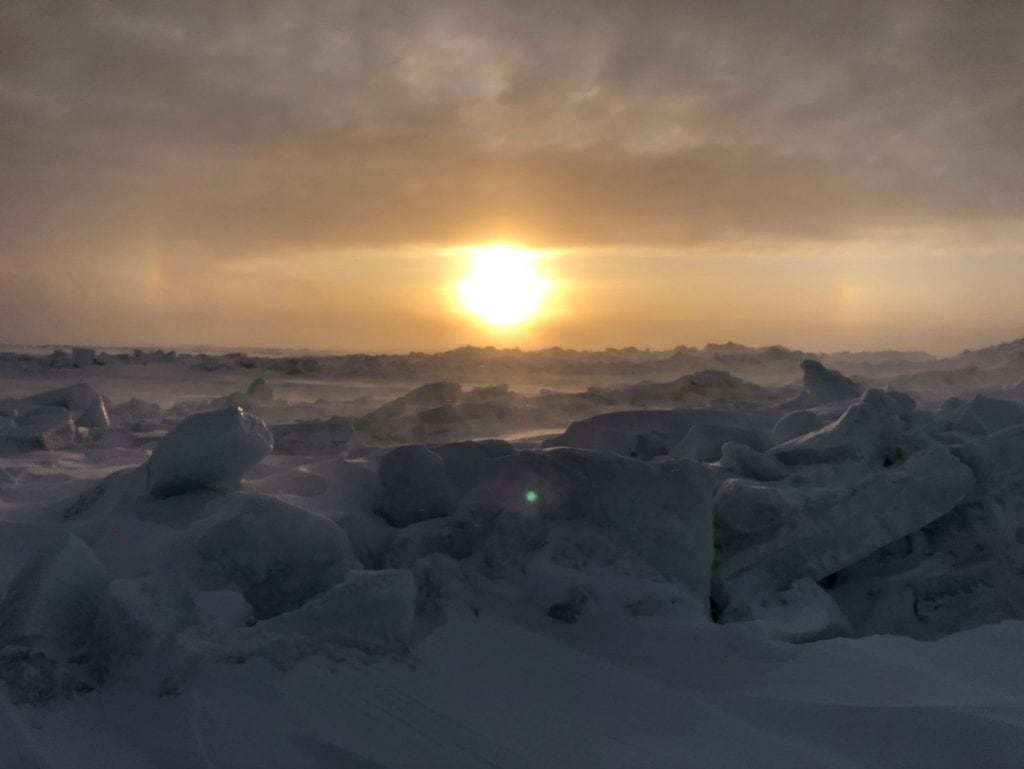
Cold regions are some of the most dynamic on the planet, experiencing intense winter storms, high winds, and rapid changes such as the loss of winter sea ice due to rising temperatures. This makes them among the most challenging environments to employ NBS. These harsh conditions limit the substrate and vegetation options. For example, vegetation options include only a few slow-growing plant species, and substrate is primarily limited to larger grain sizes, such as gravel, cobble, or rock. In addition, these remote locations can hinder both the availability and the transportation of materials. Because there are no roads into Point Hope from other villages and population centers, you must take an airplane, a boat, a snowmobile, or a dog team to access the village. The nearest village, Kivalina, is more than 100 miles away.
“The kind of designs we need to look at for cold regions are different compared to the Lower 48. It requires completely different approaches from what we typically think of as natural and nature-based features like wetlands, islands, mangroves, and reefs,” explains Jeff King, Deputy Lead of the EWN program. “We take more of a hybrid approach, usually including more hard substrate and less dependence on vegetation than in temperate areas.” To address these challenges, EWN has brought in additional researchers from the U.S. Army Engineer Research and Development Center (ERDC) Cold Regions Research and Engineering Laboratory (CRREL) and Coastal Hydraulics Laboratory’s Field Research Facility (FRF) to lead hydrodynamic and ice-cellar research that will support the development of strategies for employing NBS in cold regions.
Point Hope has significant challenges that are unique even for Alaska. Situated on a gravel spit in a dynamic high-energy environment, the town experiences winter storms and the full brunt of waves traveling across the Arctic Ocean. “The northwestern coast [of Alaska] has been frozen for thousands of years and is now thawing. Point Hope has not experienced these types of changes in recent human history, and things are changing rapidly. It’s pretty urgent for some of these villages,” said Taber Midgley, Point Hope Project Manager with EA.
In addition, thawing permafrost and loss of shorefast ice serves to increase the impacts from more-frequent and longer-duration winter storm events. “Less shorefast ice means that storms are having a greater impact in coastal systems and causing overtopping of the beach and tundra, increasing the rate of erosion and even getting seawater in their water supply,” said Nick Cohn, Research Oceanographer at ERDC’s FRF.
These hazards also increase the vulnerability and isolation of the remote community by interrupting communications and supplies and hindering logistics, administrative tasks, and planning. “Shipping things is difficult—it has to be on a barge in August. If you miss it, you have to wait a year, unless you fly it in,” said Tom Douglas, Senior Scientist Technical Manager with ERDC-CRREL. “Some things don’t fit on airplanes; throw COVID into the mix, and it makes logistics even harder.”
The absence of baseline information such as hydrodynamic, tide, and water-level data is another challenge to working in this region. “In the Lower 48 states, it is relatively easy to get accurate tidal datums, tidal gauge records, lidar topography, or bathymetry for a site. But here we are almost starting from scratch,” explained Whitin. “For example, the limited tidal-range data that does exist has not been updated since the early 2000s and does not take into account changes in sea level.” In addition, most instruments and sensors are designed and field tested in temperate regions and can fail under the extreme seasonality and harsh conditions. “During nearly half the year, it is dark, cold, and windy. The ground is frozen. Sensors break, and batteries freeze,” said Cohn.
Enhancing Project Value
The goal of this project is to come up with feasible solutions that will help delay or prevent villages from being moved away from the coast. This is the main goal.
Sam Whitin, EA
Advancing use of NBS in Point Hope is an opportunity for the project partners to work with the community to help them address their most pressing issues related to ongoing erosion, flooding, thawing ice cellars, and loss of cultural resources while incorporating traditional ecological knowledge into project designs and alternatives and advancing research and development of nature-based resilience strategies in cold regions. “This is an opportunity to advance nature-based solutions in a region where it has not been tried before using western-style science and engineering,” notes Douglas. “We will be collecting the baseline data to better understand the system and to come up with the appropriate interventions to test.”
A cornerstone of this project is the gathering and use of traditional ecological knowledge, also known as indigenous knowledge, which incorporates information and data related to the ecosystem from direct first-person experience. This project also represents an opportunity to archive traditional ecological knowledge and to inform the planning and design of nature-based alternatives in cold regions. “The community is part of the design process. Their ideas and observations go into the design. There’s no way you could do this project without engaging the community in this manner. Here, involving the community involves them in the process,” explains Melissa Becker, EA’s Senior Scientist and Manager of the Point Hope community outreach component. The importance of utilizing context-specific local knowledge and intergenerational transmission of knowledge, skills, and strategies from the Point Hope community cannot be overlooked and requires respect and care on the part of scientists and researchers who work with the community members. “It takes time to earn trust, and it is impossible to do over email and phone calls. We had to be there and talk to people, and we want to do more,” says Becker.
This project also represents an important opportunity to combine cold regions research and landscape architecture. Leveraging an existing EWN relationship created a unique opportunity to bring a team of landscape architects into the EWN cold regions working group. Sean Burkholder, Landscape Architect at the University of Pennsylvania, and Rob Holmes, Landscape Architect at Auburn University—both members of the Dredge Research Collaborative (DRC)—have partnered with EWN for years. “Rob and Sean, together with other members of the DRC, have really helped to advance the design of innovative NBS,” explains King. “Their perspectives concerning the dynamics of complex systems and options for integrating a variety of interventions is invaluable.”
Multiple skill sets and expertise are required to advance EWN practice in such harsh environments. Moreover, advancing nature-based solutions in cold regions requires an understanding of the physical processes impacting the site. “Understanding the baseline conditions—the forces acting on the landscape and how it is responding—are essential to generating nature-based approaches or natural interventions,” explains Burkholder. To address these data needs, the project team of engineers, landscape architects, program managers, ecological restoration practitioners, and community outreach specialists will integrate traditional ecological knowledge with baseline data collections, modeling outputs, and landscape architecture to inform development of project alternatives that address the threats to the road, cultural sites, and ice cellars.
Summer Field Work and Research
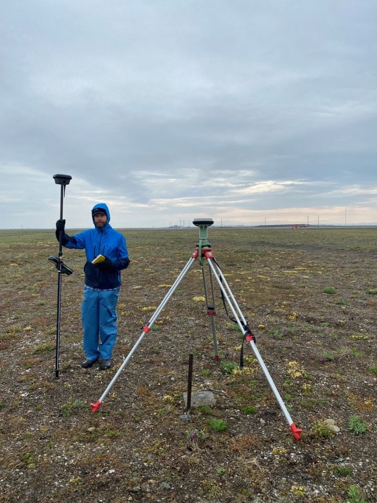
In July 2021 project partners EA, AES, and Members of the DRC and their graduate students conducted baseline mapping of the site using drones. They focused on the critical areas of erosion, such as the road, cultural sites, beaches, and thawing ice cellars. Accurate depictions of the topography combined with the true color imagery will be used to develop architectural renderings, also known as visualizations. The model surfaces will allow the researchers to detect how the landscape is changing over time. “As landscape architects, we help to bridge the understanding between the engineering and the complex cultural and ecological context of the larger landscape,” notes Burkholder. “The types of visualizations we produce are able to convey aspects of the landscape in effective ways, and are especially helpful in communicating the intricacies of natural processes to people.”
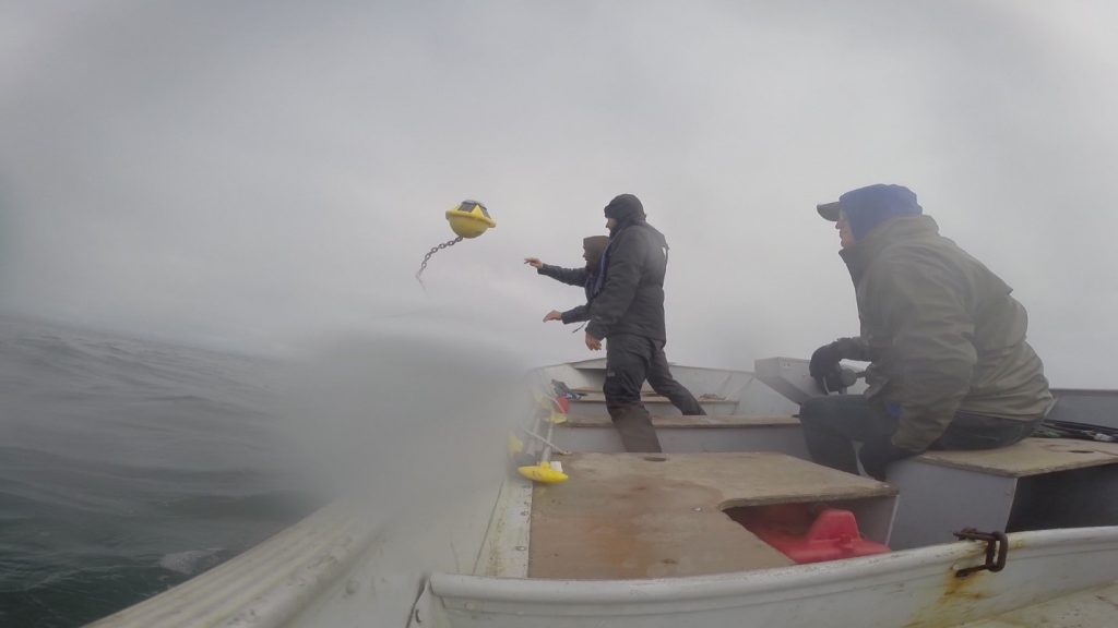
The project team also deployed instruments to collect baseline data on the waves, water level, and water temperature at the site to understand coastal erosional dynamics and interactions with thawing permafrost. Nick Cohn, with ERDC FRF, will use this data to adapt existing coastal erosion models to the Point Hope environment and to better understand the coupling between the rapidly retreating beach system and the adjacent permafrost landscape. “Most existing models are parameterized to sandy environments and are not for the types of vegetation or substrate that are found in cold regions,” notes Cohn. He will also use the data to estimate overtopping fluxes for the project alternatives to ensure the structures are likely to reduce future flooding impacts.
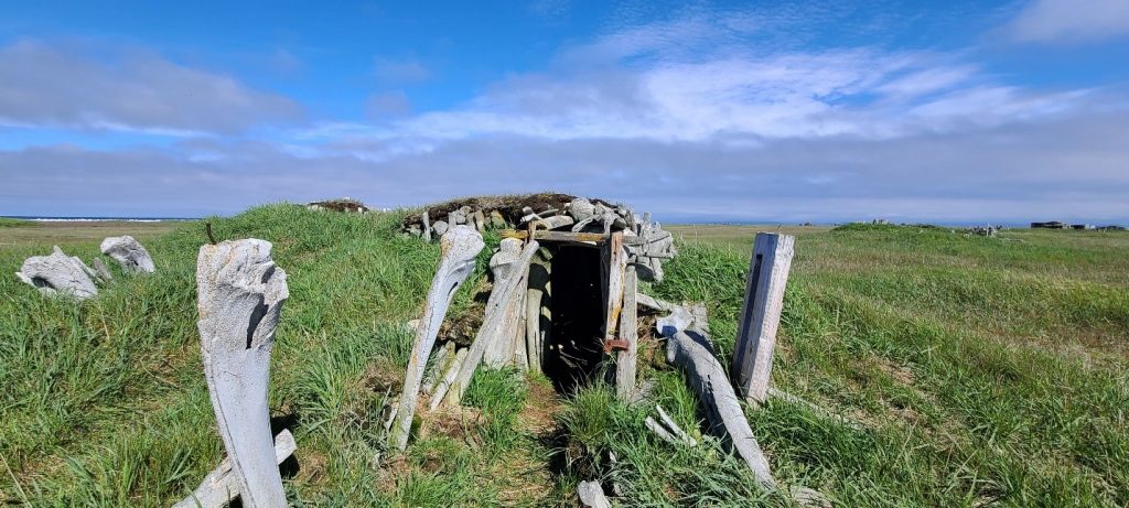
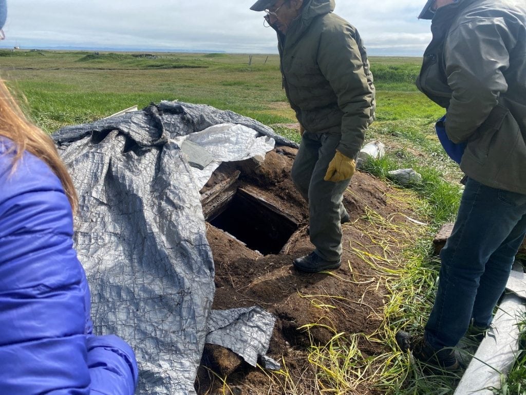
Tom Douglas, with CRREL, is using on-the-ground data collections in addition to satellite and drone imagery to investigate ice cellar permafrost dynamics to inform the placement or relocation of ice cellars for the local community. “Studying ice cellars is new. Some of them are thousands of years old, and they are dug down below the permafrost. They are literally freezers in the ground—it is how they can live in a harsh place and store their meat,” said Douglas. “But, the thawing permafrost is causing the roofs to collapse and water to seep in.” In 2021, volunteers from the local community deployed a series of thermistors (index-card-size automated temperature data loggers) in the ice cellars. Permafrost temperature combined with elevations will allow Douglas to measure the amount of thaw that occurs. “As permafrost thaws, the active [seasonally thawed] layer expands downward as you go from ice to water, causing the ground surface to subside,” he said. “These measurements will be used to create temperature and elevation cross sections that will help the community decide whether to protect or relocate ice cellars.” The data will be downloaded and analyzed in summer 2022.
In addition, Douglas and his colleague Lauren Bosche, an ORISE Research Participant at CRREL, are using high-resolution satellite imagery to approximate shoreline change rates to better understand the erosional impact of storms and trends in historical shoreline change on the northern side of the peninsula. Initial results indicate that there has been an average of over three feet of erosion per year since 1950, though the rate of change across the coastline varies considerably. Knowing the direction, extent, and timing of the shoreline change rate, such as whether shoreline change is driven by episodic storm events or sea level rise, allows the team to estimate how much the coastline will change in the future. “If we can project the locations and rates of coastal retreat, we could give them a timeframe for when they [the City of Point Hope] should move; that would be helpful,” said Douglas.
AES and EA conducted interviews in July 2021 with Point Hope residents to integrate traditional ecological knowledge into the development of the project design alternatives. Darrin Lawless, AES, acts as the liaison between the residents, the city of Point Hope, and the project team, along with his other project and grant management roles on the project. “We were happy to see scientists come into the village and participate and be well-received. It’s not a numbers game. It’s not about how many people are at these meetings; it’s who is at the meetings,” said Lawless. “When we see prominent elders walk in, we’re happy because we know that we just have to get them the right information in order to inform the design process.”
Next Steps
The visualizations developed by the landscape architects will be presented to the City of Point Hope in early 2022 as a series of project design alternatives for review and prioritization. While there currently is no money for construction, the project team believes there is a high likelihood of winning additional grant opportunities to continue design, permitting, and construction for some of these projects. “The primary goal is to get the community to look at possibilities and try to identify a project—or several projects—that can actually be completed,” said Lawless.
The project team also plans to collect more baseline data in 2022 and to continue to engage with the local community to learn more about their best practices for maintaining their ice cellars. Taber Midgely emphasized, “We have a better understanding now of data needs and how to do things a little better. We also have relationships with community members now. We want to get up there and get more data to inform these designs and future work.”
The Point Hope project may be a springboard for other cold regions. . . . All of the approaches are transferable.
Nick Cohn, ERDC FRF
Overall the project team hopes to improve resilience and promote mitigation efforts with long-lasting benefits for the community, while also obtaining a repository of information on successes and failures that projects in similar regions can reference. For example, guidance and lessons learned from Point Hope will be transferable to other regions within Alaska, as well as cold regions within Canada, New England, and the Great Lakes. As Whitin explains “We are hoping that we can promote these ideas so these practices will be adopted more broadly in cold regions.”
References/Links
Tikigaq: Resilience in Point Hope
Engineering With Nature + Landscape Architecture Tikigaq / Point Hope