Search
Close this search box.
August 18, 2023

Advancing Coastal Monitoring and Shaping Future SAR Satellite Systems

  • news

Coastal stakeholders need monitoring solutions to evaluate the effectiveness of dredged material for combating sea level rise in back-bay environments. In response, EWN researchers have partnered with Syracuse University’s Civil and Environmental Engineering Department to explore the viability of employing satellite-derived data for studying back-bay sediment nourishment, linking USACE needs with NASA’s working group tasked with designing the next domestic synthetic aperture radar satellite platform.

Figure 1. workflow of computational pipeline for generation of monthly coastal indices (MCIs) and management reports This figure has the Jupiterhub logo at the top left. Column a shos a header titled "User inputs". Below that is 3 boxes, labeled "POI", "AOI", and "Data output options". Column b has a bubble titled "NASA DAAC/USGS Earth Explorer/Google EE API" with 3 boxes below, labeled "Imagery Search", "Imagery Preprocessing", and "Processed imagery download". Column c shows a bubble labeled "Coud server, below which are 4 boxes, labled "Index extraction", "Error modeling", "Management report (Q2)", and "Export data". Arrows connect POI and AOI to Imagery search. An arrow connects Processed imagery download to Index extraction. An arrow connects Data output options to Export data. Two arrows connect Export data and point down to 2 graphics, a series of overlapping squares, labled "MCI gridded time series (netCDF)" and a yellow rectangle labeled "Report data (.csv and geotiff)".

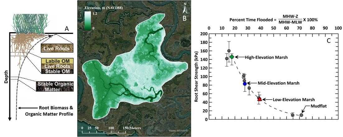
Sediment erosion, deposition, and land subsidence are key influencers of relative sea level rise, and USACE combats these challenges through beneficial use of dredged material (BUDM). Addressing the complexity of shifting coastal topography requires tailored management strategies. A lack of historical, recurring observations hampers our ability to quantify impacts, patterns, and trends in coastal change across different drivers.

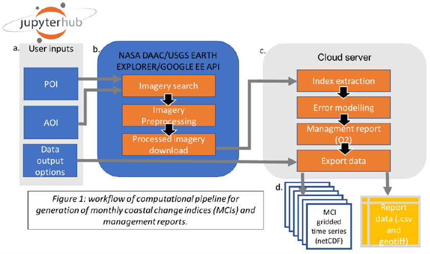
Dr. Elizabeth Carter’s team at Syracuse University will work with the Engineer Research and Development Center to develop an operational dataset of vital coastal change parameters, vertical displacement, and dynamic land-sea masks. Leveraging open-source, portable software, the team will extract information from publicly available imagery archives from multiple satellite platforms, facilitating management-relevant data summaries. This demonstration will use existing satellite data for immediate coastal monitoring needs at active BUDM sites.

Recognizing the dynamic evolution of earth observing satellites, Syracuse University will assess the potential of the current satellite fleet to meet novel monitoring demands of USACE. The results will be shared with USACE-ERDC and the NASA Surface Deformation and Change (SDC) working group, influencing the design of the next-generation synthetic aperture radar (SAR) satellite platform.

Research Projects

This project will refine remote sensing techniques to monitor morphological and ecological trends of beneficial use o...
Facebook
Twitter
LinkedIn
Email

More Posts

Research Update: Innovative Sensor Deployment to Save New Jersey Wetlands

Research Update: Innovative Sensor Deployment to Save New Jersey Wetlands

Scotch Bonnet, NJ – Researchers from the U.S. Army Engineer Research and Development Center’s Coastal…
Network for Engineering With Nature (N-EWN) Inaugural Partner’s Symposium

Network for Engineering With Nature (N-EWN) Inaugural Partner’s Symposium

The inaugural Network for Engineering With Nature (N-EWN) Partner’s Symposium, held from May 22-24, 2024,…
New Book Showcases Nature-Based Solutions Around the World

New Book Showcases Nature-Based Solutions Around the World

We are pleased to announce the release of Engineering With Nature: An Atlas, Volume 3.…