18
April
2024
EWN Engagements

N-EWN Seminar: CarbonWATCH–Assessing your carbon inventory at the landscape level using geospatial technology

Purpose

As climate change becomes an increasing threat, and organizations across the globe are setting ambitious net zero and environmental, social, and governance (ESG) goals, assessing, inventorying, and monitoring carbon stock in plants and soils has become vitally important to a variety of businesses and sectors. Stantec’s CarbonWATCH tool measures the amount of carbon dioxide equivalents (CO2e) present in vegetation and soil and can be deployed in any ecosystem for a wide variety of industries and professionals. Using a combination of high-resolution imagery, LiDAR, vegetation species allometric models, and artificial intelligence/machine learning, we can quantify CO2e in reclamation sites and\or mature natural capital locations faster and more accurately than traditional methods. During this webinar, participants will learn about the carbon markets, needs, the measurement, reporting, and verification (MRV) process verses traditional monitoring methods, and how CarbonWATCH is utilized to streamline carbon measurements in vegetation and soil.

CarbonWATCH–Assessing Your Carbon Inventory at the Landscape Level Using Geospatial Technology Presenters: Grant Wiseman, Remote Sensing Technology Manager, Stantec; Brendan Player, Nature-based Carbon Solutions Team Lead, Stantec; Dr. Martha Farella, Data Scientist, Stantec As climate change becomes an increasing threat, and organizations across the globe are setting ambitious net zero and environmental, social, and governance (ESG) goals, assessing, inventorying, and monitoring carbon stock in plants and soils has become vitally important to a variety of businesses and sectors. Stantec’s CarbonWATCH tool measures the amount of carbon dioxide equivalents (CO2e) present in vegetation and soil and can be deployed in any ecosystem for a wide variety of industries and professionals. Using a combination of high-resolution imagery, LiDAR, vegetation species allometric models, and artificial intelligence/machine learning, we can quantify CO2e in reclamation sites and\or mature natural capital locations faster and more accurately than traditional methods. During this webinar, participants will learn about the carbon markets, needs, the measurement, reporting, and verification (MRV) process verses traditional monitoring methods, and how CarbonWATCH is utilized to streamline carbon measurements in vegetation and soil.

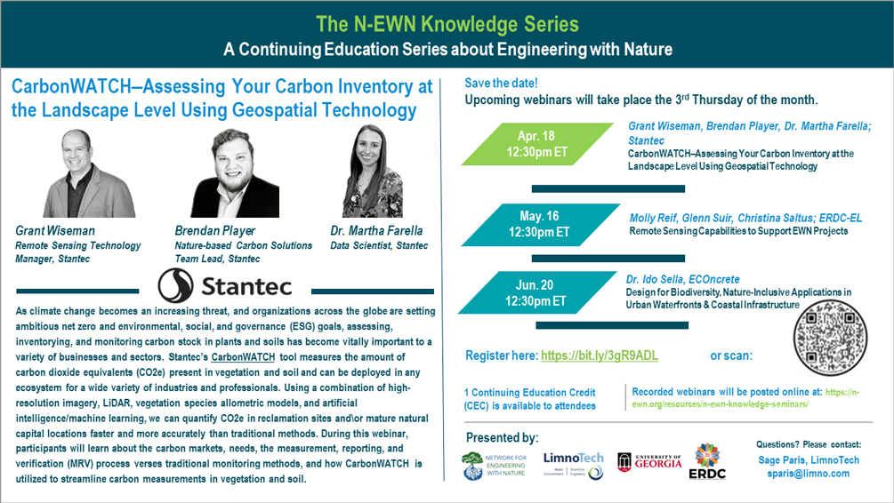
The Network for Engineering With Nature® (EWN) invites you to the N-EWN Knowledge Series: A Continuing Education Series about Engineering with Nature—CarbonWATCH–Assessing Your Carbon Inventory at the Landscape Level Using Geospatial Technology with Grant Wiseman, Brendan Player, and Dr. Martha Farella (Stantec). This 1-hour Zoom webinar took place April 18, 2024 at 12:30pm ET.

For previously recorded seminars, please visit the N-EWN Seminars page.

What's Next

Resources:

Point of Contact

Data Scientist, Stantec

Nature-based Climate Solutions Team Lead, Stantec

Remote Sensing Technology Manager, Stantec

Facebook
Twitter
LinkedIn
Email

More Engagements

Recent Engagements

EWN Engagements

Related To This Engagement

Play Video
The Network for Engineering With Nature® and the National Academies of Sciences, Engineering, and Medicine hosted a National Nature-Based Solutions......
Play Video
The Network for Engineering With Nature® and the National Academies of Sciences, Engineering, and Medicine hosted a National Nature-Based Solutions......
This project aims to harmonize water resources infrastructure, such as reservoirs and levees, with agricultural land management across the U.S., pr......
Loading More