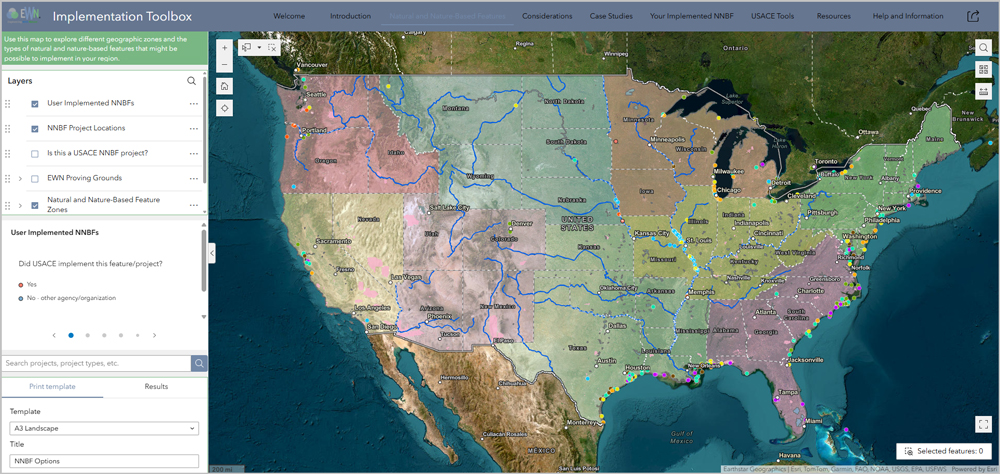
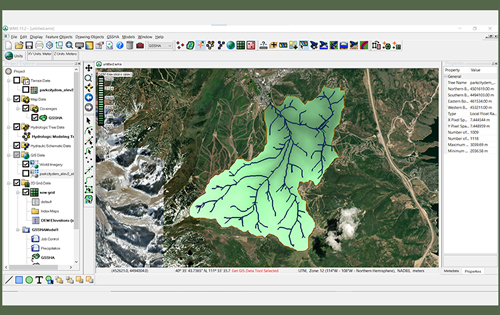
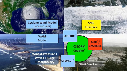
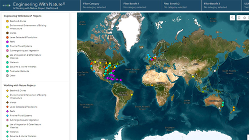
Natural Infrastructure Opportunities Tool
The public facing Natural Infrastructure Opportunities Tool (NIOT), developed in collaboration with the Natural Infrastructure Initiative, focuses on identifying natural infrastructure and beneficial use opportunities. Through map-based visualizations of environmental, geomorphic, and sediment conditions, as well as upcoming USACE projects, and an interface for users to add their resource needs and resource availability, this portal will help discover natural infrastructure connections and inspire innovative opportunities.
The aim of the viewer is to provide a data informed perspective for multiple stakeholders with the goal of finding mutually beneficial strategies to improve and increase investment in the use and creation of natural infrastructure. The viewer is intended to be used in collaboration, as a platform to generate new ideas about natural infrastucture projects during the planning stages.
The NIOT viewer was developed through iterative collaboration with representatives from Caterpillar Inc., The Nature Conservancy, Great Lakes Dredge and Dock, AECOM, USACE ERDC and USACE Mobile District. The viewer brings together datasets from multiple sources in one place and also allows users to identify current infrastructure projects, and directly add resource or project needs. Resource connections, as well as points of contact, are integrated into supporting databases and appear on the viewer map. The viewer includes national and regional datasets, and also provides users the option to request the addition of user-identified geospatial data layers, allowing NIOT to be adapted for regional use and fine tuned for local application.
- Type: Web application
- User: Public and USACE
- POC: Safra.Altman@usace.army.mil
- NIO Tool User Guide
- Visit Natural Infrastructure Opportunities Tool web application
Engineering With Nature Project Mapper (ProMap)
ProMap is a geography-based data viewer for projects that fit within the EWN context. The aim of the mapper is to allow users to explore information that can be helpful in developing EWN ideas during the planning of their own projects. Projects can be viewed based upon infrastructure type (e.g., dredging project, breakwater, lock & dam) or by their intended environmental or social benefits.
- Type: Web Application
- User: Public and USACE
- ProMap Platform Presentation (PDF Too Large)
- ProMap Poster Presentation
- ProMap ERDC Technical Note
- Visit EWN ProMap web application
EWN ProMap is an interactive geospatial map viewer containing water resources projects which fit within the EWN definition of intentionally aligning natural and engineering processes to efficiently and sustainably deliver economic, environmental, and social benefits through collaborative processes. In addition to EWN projects, ProMap includes Working with Nature (WwN) and EcoShape projects.
Projects in ProMap can be displayed ranging from the global scale to the project scale by using the zoom tool. Using the Map Layers, projects can be displayed by the associated infrastructure project type (AIPT) (e.g., navigation dredging, breakwater, chevron, etc.) or the project designers’ intended EWN benefits (Benefit 1, Benefit 2, Benefit 3) (e.g., vegetated habitat, beach nourishment, fish habitat, etc.).
The AIPT defines the goal of the original infrastructure project itself and not the EWN benefits. For example, when a channel is dredged and the sediment is used to create a wetland, the AIPT is Navigation Dredging (a channel, anchorage, turning basin, or other such feature). The EWN benefits depend on the original targeted resources of the project, which for this wetland creation example could reasonably be Benefit 1: vegetated habitat, Benefit 2: bird habitat, and Benefit 3: fish habitat. The project might also benefit other resources, such as invertebrates or provide aesthetic or recreational benefits, but those are in addition to the primary intent of the proponents. The key intent of the EWN benefits is to focus on the primary targeted resources.
When an AIPT or particular EWN benefit is selected by the user, the display will populate with all of the possible site candidate types in the database. Thus, if a user is interested in ideas associated with breakwaters or sites that are intended to provide fish habitat, they will be able to quickly narrow their search by checking on and off in the Map Layers. The Map Widget panel also allows the user to find specific sites using a keyword search. The user is able to view site attribute information by clicking on a site icon. The site icon pop-up bubble provides non-spatial information including the site description, data files, site images, and hyperlinks.
The Map Widget panel also allows the user to change the basemap (e.g., imagery, topographic, etc.), measure a site by area or distance and determine the latitude/longitude, and create a printout of a point of interest.
EWN ProMap also has a function that allows users to submit sites that they believe should be included in the database. The process is initiated by the user clicking on the Submit Study link in the top, right of the page. The user should fill out the form in its entirety and either enter the latitude/longitude or select the site location on the map and click submit. The submit button is used to send the data to the EWN administrator for review and approval. Once the site is approve for inclusion, an administrator will be in contact to retrieve additional project information and supplemental data as needed.
Do you have a project that you think should be included in our EWN ProMap? Consider the EWN essential ingredients which have been rephrased as criteria that can be used to describe the degree to which a project applies the EWN concept. These criteria are:
- Extent to which natural processes are used to produce benefits and outcomes.
- Extent to which the project and its configuration broaden the base of benefits provided (economic, social, and environmental).
- Extent to which the project makes use of collaborative processes to organize and focus interests, stakeholders, and partners.
- Extent to which the project produces and makes use of efficiencies to contribute to sustainable delivery of project benefits, including consideration of how the project function is sustainable in the broader systematic context (e.g., regional watershed or sediment systems).
Thin Layer Placement (TLP)
A new website dedicated to the practice of thin layer placement of dredged material is now available. The ultimate goal of the site is to consolidate all information and data available from projects and literature relevant to thin layer placement as a living resource. The website contains a growing body of searchable resources pertaining to all stages of dredged material based beneficial use projects, including those pertinent to conceptualization, design, implementation and long-term management.
- Type: Website
- User: Public and USACE
- TLP Platform Presentation (PDF Too Large to Upload)
- TLP ERDC Technical Note
- Visit TLP website
USACE Navigation Portal
USACE staff collect, store, visualize, analyze, and distribute huge amounts of navigation-related data. The Navigation Data Integration Framework (NDIF), which forms the basis of this Navigation Portal, is an effort to establish a detailed methodology to link data and tools across the Navigation Business line and make them easily available to our stakeholders.
- Type: Website
- User: Public and USACE
- Visit USACE Navigation Portal
Dredging Technologies
A tool to identify appropriate models based on selected criteria.
- Type: Web application
- User: Public and USACE
- Visit Dredging Technologies website
Dredging Operations Technical Support (DOTS) Applications
DOTS houses several dredging related models and applications including FishRand-Migration Probablistic Bioaccumulation Model (FR-M), the Dredged Material Disposal Management model (D2M2), and DREDGABL.
- Type: Website
- User: Public and USACE
- Visit DOTS website
Beneficial Use of Dredged Material (BUDM)
BUDM is an ERDC website dedicated to increasing the public awareness of using dredged material as a valuable resource. Beneficial use of dredged material has become a viable alternative to traditional “dredge and dispose” methods for many projects. Environmental, economic, social, and other benefits can be derived from the productive use of dredged material. Dredged material is increasingly used beneficially for a greater variety of projects and purposes.
- Type: Website
- User: Public and USACE
- Visit BUDM website
Sediment Analysis and Geo-App (SAGA)
Comprehensive web application, tools, and database for entering, organizing, analyzing, and presenting coastal and riverine sediment sampling events (borings, grab samples, wells, and sediment monitoring locations such as river gages or riverine monitoring areas), testing (chemical, biological, or physical) results, and related reports.
- Type: Web Application
- User: Public and USACE
- Visit SAGA website
Steady State Spectral Wave (STWAVE)
Coastal environments are in a constant state of flux because of wave action. Waves move sediments, erode shorelines, drive currents, disrupt navigation, and excite harbor oscillations. To manage successful coastal engineering projects by understanding the complex changing environment, the ERDC Coastal and Hydraulics Laboratory (CHL) created an innovative numerical wave modeling technology called the Steady State Spectral Wave (STWAVE).
- Type: Model
- User: Public and USACE
- STWAVE manual (PDF)
Particle Tracking Model (PTM)
PTM has been developed to accurately predict the fate of sediments and other water-borne particulates to aid coastal engineering and dredged material management. PTM can be used to assess the impact of dredging and placement operations on contaminant transport, sensitive habitat, endangered species, rehandling, and beneficial use. PTM has a user friendly interface within the Surface-water Modeling System (SMS) that provides effective visualization for model results. SMS is free for all USACE employees and can be purchased for private use. To learn more about PTM visit the Dredging Technologies website.
- Type: Model
- User: Public and USACE
- POC: Tahirih.C.Lackey@usace.army.mil
- POC: Joe.Z.Gailani@usace.army.mil
- Visit Dredging Technologies website
- Visit SMS website
Long Term Fate (LTFATE)
Investigate the long-term fate and stability of dredged material disposal sites. This information can provide an estimate of long-term material fate for use in determining whether a disposal site will be dispersive over time. LTFATE is mainly used by USACE employees. The model is data intensive and requires training to use correctly. LTFATE is available by request only. To learn more about LTFATE visit the Dredging Technologies web tool. This tool helps to identify appropriate models based on selected criteria.
- Type: Model
- User: Public and USACE
- POC: Earl.Hayter@usace.army.mil
- POC: Joe.Z.Gailani@usace.army.mil
- Visit Dredging Technologies website