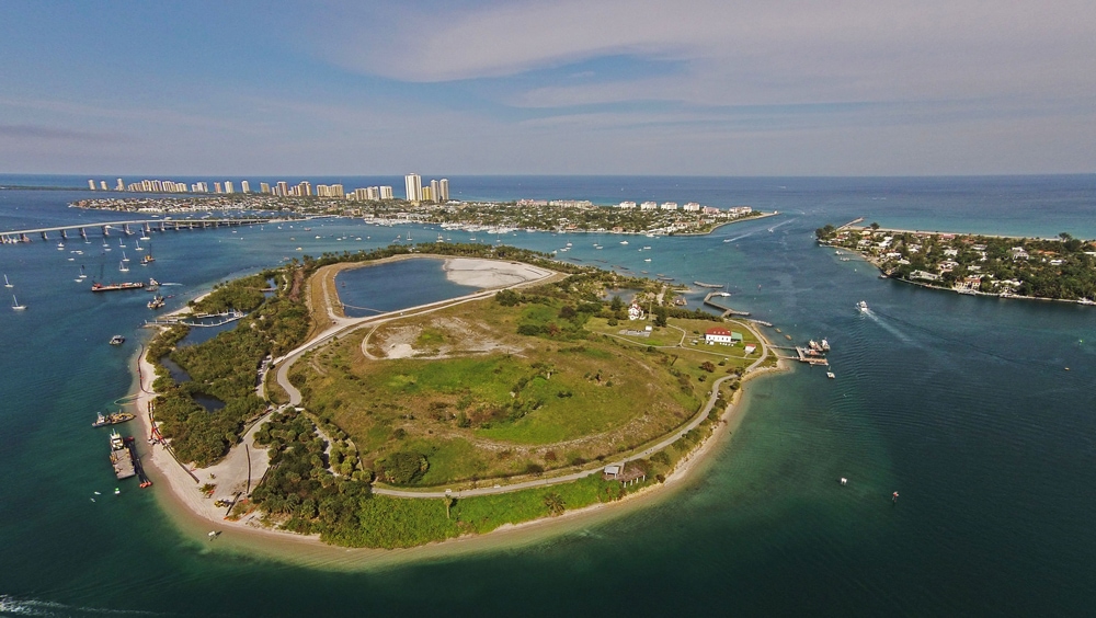
Peanut Island, located in the Lake Worth Lagoon (LWL) within Palm Beach County, Florida, was originally created in 1918 using the material excavated when the Lake Worth Inlet was created (Figure 1). First called Inlet Island, the island was renamed Peanut Island for a planned peanut oil-shipping operation which failed in 1946. The island originally encompassed only ten acres (4.0 hectares). By 1923 the Port was using the island as a spoil storage site for the maintenance of the inlet and the Port shipping channel. In 1991 the Port sold the northern half of the island to the Florida Inland Navigation District (FIND) as a spoil storage site for Intracoastal Waterway maintenance dredging.
Today, as a result of continued sediment deposition from maintenance dredging, Peanut Island comprises approximately 86 acres (34.8 hectares). The primary use of the island will continue as a spoil storage site, but the Port Authority and FIND have made the perimeter of the island available to the public as a park through a long-term arrangement with Palm Beach County. The park hosts facilities for passive and active recreational use that includes beaches, swimming/ snorkel areas, picnic and camping areas, docking facilities, a fishing pier, sidewalks, trails throughout the island and environmental enhancement areas.
Project Description
In 1996 a public park at the northeast corner of the island, a 10-foot wide concrete hiking trail around the island perimeter, a snorkeling area, a barge docking facility with proposed bulkhead and spoil access road, an observation deck and restroom facilities were authorized. In addition, the proposed park itself consisted of a campground, picnic areas, ranger station and maintenance building, restroom with shower, a boat dock and fishing pier.
In 1998, Palm Beach County Environmental Resources Management (ERM) began planning a habitat enhancement project at the Lake Worth Golf Course of which the Peanut Island makeover project included offloading 1.2 million cubic yards of spoil to Snook Islands.
In 2002 the addition of two floating ADA compliant docking structures were authorized as well as flushing channels to restore existing mangroves where realigned to further minimize mangrove impacts and modification of the mangrove boardwalk.
Reef Sites: Peanut Island has four separate reef sites. The fishing pier and east dock sites contain concrete tetrahedrons, modules and caprock deployed in 2000 and 2011. Major enhancements occurred on the Island in 2005, including creation of the 10’ deep snorkel reef which is protected by limestone and granite boulders. Between 2006 and 2012, 6 breakwaters were added on the east and south sides of the island. These multiple structures encompass 1.7 acres in depths ranging from 2 to 4 feet.
Breakwater Reefs (2008): Limestone rock (500 tons) was used to construct three breakwaters on Peanut Island’s shoreline. One breakwater was constructed on the east side of the island and two smaller structures were installed on the southeastern shoreline. The structures not only slow beach erosion and provide shoreline protection, they also provide reef habitat. The breakwater reefs are very popular with snorkelers and provide a variety of restored habitats for fish, invertebrates, and birds.
Lagoon/ Shoreline Restoration (2009): Sand was dredged from the Peanut Island boat docks and fishing pier and reused onsite to stabilize the beach and prevent further erosion of the walking path. The sand was also used to recontour the snorkeling lagoon and create 0.4 acres of intertidal Spartina (salt marsh cordgrass) habitat which stabilizes the shoreline, increases nutrient uptake, and provides important wildlife habitat.
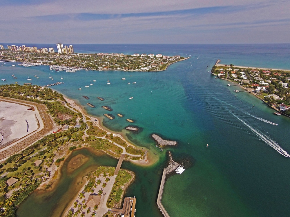
Breakwaters and Reef Improvements (2012): The project was designed to improve the tidal flow within the snorkeling reef system and provide increased shoreline protection and reef habitat on the island’s east shore (Figure 2). The existing rock infrastructure was modified due to the area experiencing ongoing problems with poor water quality and minimal tidal flushing, so the removal of 720 tons of granite rock that was placed in a Y-shape groin and additional 1,300 tons of granite rock along the southwest lagoon side occurred. The rock was relocated to create a breakwater structure to reduce wave energy and protect a walkway along the eastern shoreline. Additionally, 890 tons of granite was placed behind two breakwaters to enhance the areas. These breakwaters provide shoreline protection as well as artificial reef habitat in an area that is void of natural resources. The reef system is utilized by snorkelers due to the clear oceanic water, fish, coral, and other reef resources that it provides as it is located adjacent to the Lake Worth Inlet.
Additional enhancement activities were permitted in 2013 for the installation of two 110-foot long emergent reef structures for shoreline protection and reduction in wave energy as well as providing artificial reef habitat for both marine life and recreational snorkeling. Also permitted was the placement of limestone rocks in discrete piles to create an artificial snorkel reef trail within two separate areas on the eastern side of the island.
Monitoring & Study Results
The snorkel reef was monitored in 2007, 2008, and 2012. A total of 26 families and 63 species of fish were recorded. Haemulidae (grunt) and Scaridae (parrotfish) were represented by the most species with 11 and 10 species respectively. Unusual sightings included a black grouper (Mycteroperca bonaci) juvenile.
During the 2007 site visit only two years after the limerock boulders were installed, five hard coral species and a gorgonian were observed. Unusual sightings included spaghetti worms (Eupolymnia crassicornis) and an unidentified octopus. The site visit in September 2012 documented 12 different species of corals. Several of these corals have attained larger sizes, such as 30 cm for boulder brain coral (Colpophyllia natans) and 20 cm for symmetrical brain coral (Diploria strigosa). Other species of note were several sponges, urchins, clams, and tunicates. Due to the proximity to the inlet, this area is bathed semidiurnally by clear Gulf Stream waters, which make this a unique and diverse reef.
Project Significance
The projects at Peanut Island have improved tidal flushing to northern LWL, providing needed habitat and recreational opportunities. Peanut island also provides a buffer to the city of Riviera Beach reducing shoreline erosion.
USACE has the authority, provided by Section 1135 and Section 206 of the Water Resources Development Act of 1986, as amended, to plan, design and construct fish and wildlife habitat restoration measures. The Corps has partnered with Palm Beach County to construct many restoration projects within the LWL through the Section 1135 program including, Munyon Island, Snook Islands and John’s Island Restoration Projects.
References
Proceedings of the 34th Annual Conference on Ecosystems Restoration and Creation 2007. Institute of Florida Studies.
Peanut Island, Lake Worth Florida