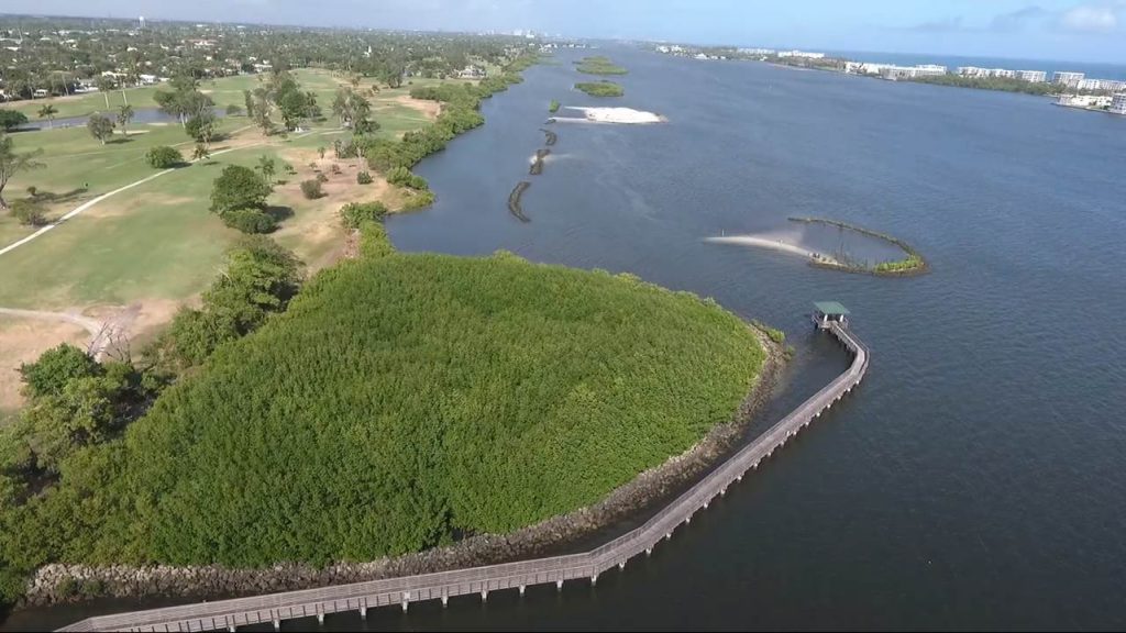
The Snook Islands project site is located adjacent to the Lake Worth Golf Course (LWGC) in the Lake Worth Lagoon (LWL) in central Palm Beach County, Florida. The LWL is a 22 mile (35.5 km) long coastal lagoon with two oceanic inlets (Figure 1).
In the late 1800’s developers began dredging and filling the wetland edges of Lake Worth Lagoon, an activity that would continue into the 1970s. Inter- and shallow sub-tidal resources were decimated. Marinas and hundreds of private docks are scattered along the shoreline. Approximately 81% of the lagoon shoreline is bulkheaded, while only about 19% of the shoreline remains fringed by mangroves.
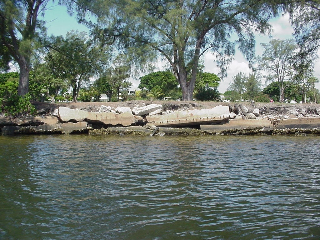
The Lake Worth Golf Course (LWGC) has approximately 1.2 linear miles (1.9 km) of shoreline along the western shore of central Lake Worth Lagoon. The existing upland portions of the LWGC were created through the dredging and filling of inter- and sub-tidal wetland resources and associated bulkhead construction. These dredge and fill activities along the shoreline resulted in a steep littoral profile, with elevations dropping quickly from +4.0 feet referenced to the National Geodetic Vertical Datum of 1929 (NGVD) at the shoreline to -7.0 feet NGVD just offshore. This steep grade minimized the area suitable for development of inter- and shallow sub-tidal resources such as mangroves, seagrasses, and oyster reefs. In addition, open water dredge holes as deep as -23.0 NGVD existed prior to construction prior to Snook Islands construction, and depths below -10.0 NGVD were common. Prior to construction of Snook Islands, over one-half of the existing shoreline was fringed with three species of mangroves (red: Rhizophora mangle, black: Avicennia germinans, and white: Laguncularia racemosa), inter-mixed with exotic Australian pine (Casuarina sp.) and Brazilian pepper (Schinus terebinthifolius). The bulkhead along the LWGC failed over time, leading to erosion of the shoreline from wind and wake-generated wave energy (Figure 2).
Project Description
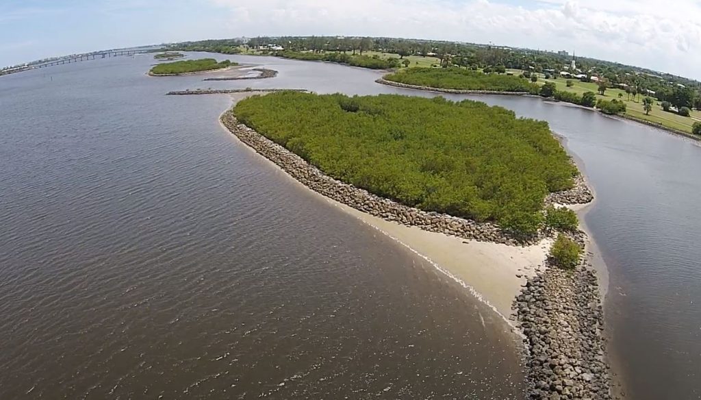
In 1998, Palm Beach County Environmental Resources Management (ERM) began planning a habitat enhancement project at the LWGC. Given that dredging and the bulkheading of the shoreline to create the golf course, eliminated areas suitable for re-establishment of inter- and shallow sub-tidal biotic communities the only viable option to remediate the loss of habitat was to place fill in the water to reconstruct sediment topography and depths appropriate for establishment of inter- and shallow sub-tidal vegetation. Peanut Island, a spoil storage site for the maintenance of Lake Worth Inlet and the Port of Palm Beach shipping channel, was a ready source of dredge spoil as the island’s spoil storage was at capacity; and an island makeover was in the final planning stages for Peanut Island. Approximately 1.2 million cubic yards of spoil was transport 10 miles from Peanut Island to the Snook Islands. This amounted to over 1,560 barge loads of sediment resulting in the creation of 10 acres of red mangroves, 2.8 acres of Spartina marsh, 2.3 acres of oyster reef, and approximately 50 acres of seagrass recruitment area. Approximately 28,000 tons (25, 401 metric tons) of 1-3 ft (0.3-0.9 m) diameter limestone boulder riprap was used to create the oyster reefs and mangrove planting breakwaters (Figure 3).
In addition exotic vegetation from approximately 5 acres (2 hectares) of the LWGC shoreline was removed and approximately 1,800 ft shoreline armor (rip rap, concrete rubble, and collapsed seawall) was removed, except in areas where the seawall was still intact and buried in situ.
Monitoring & Study Results
The project was completed in June 2005 and resulted in creation of 10 acres of red mangroves, 2.8 acres of Spartina marsh, 2.3 acres of oyster reef, and approximately 50 acres of seagrass recruitment area. Project construction eliminated the original shoreline armor along the golf course, and replaced it with a soft, vegetated shoreline. The offshore islands and oyster reefs provided protection from wind and wave energy, stabilizing the formerly eroding shoreline. In 2004, Hurricanes Frances and Jeanne made landfall near the project site. Because the project was well underway, no damage was sustained to the project or to the LWGC shoreline.
Red mangroves
The planted red mangroves achieved a survival rate of approximately 80% after two years. The mangroves were collected as propagules by volunteers and raised in a nursery to the 6 to 8 leaf stage. They were then planted on 10 different occasions by volunteers as construction of the islands and shoreline planters was completed.
Spartina
The Spartina was planted by the contractor as each section of shoreline was completed. The plantings coalesced in approximately two years.
Oysters
Oysters (Crossastrea virginica) have colonized the oyster reefs and base of the mangrove planting wave breaks. The fill used for project construction had 30% by volume of rock rubble intermixed. Oysters have also colonized the shoreline areas where the rubble is exposed. No oyster counts have been completed as yet, but visual observations suggest significant coverage.
Seagrass
Three species of seagrass occur in the project vicinity: Halophila decipiens, Halophila johnsonii, and Halodule wrightii. H. johnsonii, listed as a threatened species, is the most abundant on site as it is throughout the LWL. H. johnsonii was observed recruiting to the newly placed fill even as construction and associated turbidity continued.
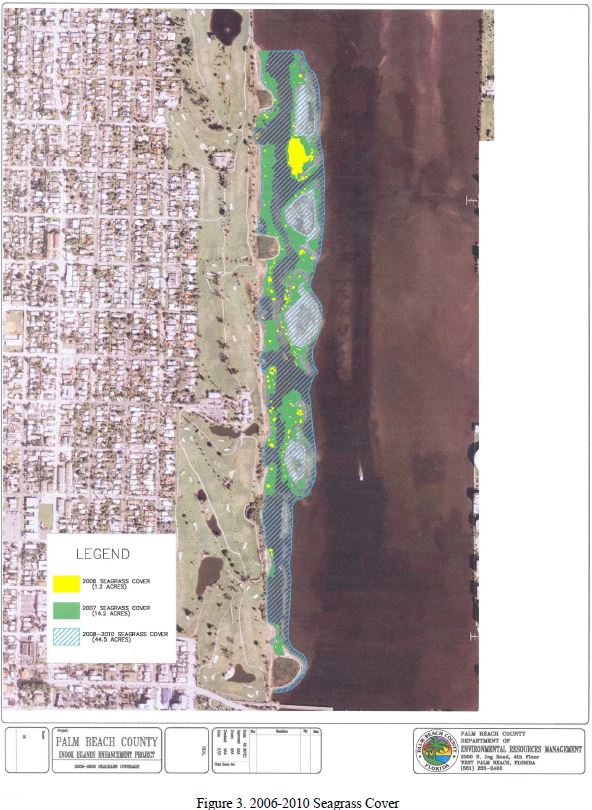
The first post-construction seagrass inventory was conducted during summer 2006. The survey method involved visiting the site at the lowest of low tides and wading the shoreline to a depth where the bottom was no longer visible. Wire survey flags were placed around the edges of the observed grass beds, which were mapped using GPS to sub-meter accuracy. This method proved effective for one-third to one-half of the potential seagrass areas. The results of the 2006 survey show that H. johnsonii has become established along the entire 1.2 mile length of the project, covering a total of 1.2 acres (0.5 hectares). Only a few small beds of H. decipiens were observed. Densities of both species were high wherever they occurred.
A second survey was performed during summer 2007. Seagrass coverage had increased by more than 10 times to 14.1 acres (5.7 hecrtares). H. wrightii was observed in at least two locations, and cover of H. decipiens was increasing. H. johnsonii still represented roughly 90%-95% of the seagrass present. From 2008 to 2010 seagrass acreage increased from 1.2 to 44.5 acres. (Figure 4).
Wildlife
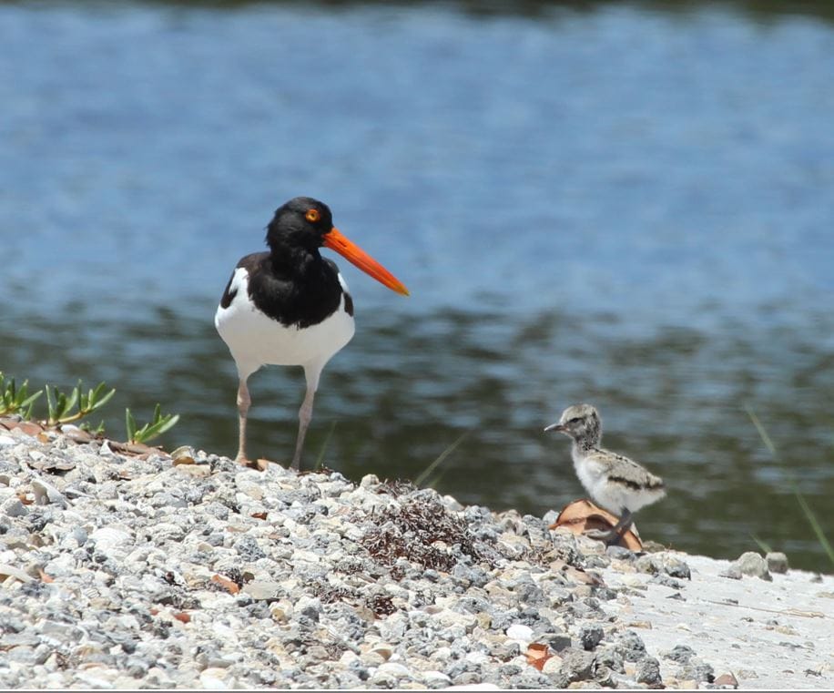
Fish and wildlife usage of the project site increased dramatically after construction. Prior to construction, there was a seawall with an immediate drop into an anoxic dredged hole. Construction created a gradually sloping inter-tidal wetland shelf, and shallow submerged areas recruiting seagrass. Wading birds, shorebirds, and ospreys regularly use the site as feeding and resting areas. Schools of juvenile fish are swimming in the shallows and around the Spartina at high tide. Manatees have also been observed feeding on the Spartina. A pair of American oystercatchers (Haematopus palliatus), listed a Species of Special Concern in Florida, appeared in 2004 and have been nesting each year on top of the mangrove riprap wavebreak. They successfully fledged a chick in the summer of 2007. American oystercatchers have since continued to successfully nest and fledge multiple chicks yearly. Currently there are 4 nesting pairs of oystercatchers utilizing the spoil islands. Recent counts within the LWL have averaged with a 81 percent overall fledge success and number of total fledged chick of 29 (Figure 5).
Project Significance
This project provided an opportunity to add almost 100 acres of inter-tidal and shallow sub-tidal resources to the Lake Worth Lagoon. Projects such as this are necessary to offset the historic loss of natural resources. Living shorelines provide an alternative to seawalls and armoring by reducing shoreline erosion. Constructing the offshore mangrove islands and oyster reefs provided an increased buffer against waves and boat wakes precluding the need to construct a new seawall, as well as restoring valuable fish and wildlife habitat. Public use amenities, including a boardwalk, fishing pier and kiosks, educate the public on the importance of living shorelines, while the day-use docks provide boater access to downtown Lake Worth, generating revenue for local businesses.
In 2012 the Snook Islands Natural Ara Public Use Facilities were created to allow visitors to view wildlife, fish, and explore the lagoon waters. Public-use components includes a boardwalk with observation platform, fishing pier, kayak launch structure, day-use docks, boat trailer parking, bike racks, benches, and informational kiosks.
Snook Islands Wetlands Restoration Phase II begun in 2013 which included the construction of two mangrove islands and oyster reefs. The additional habitat created included 0.45 acres of oyster reef, 0.74 acres of red mangroves and 7.17 acres of additional seagrass habitat. The additional open areas were created to improve bird use of the shoreline and mudflats, as well as increase utilization for fish and other wildlife.
References
FIND SINA Wetland Mitigation Fourth Annual Monitoring Report 2019. Palm Beach County Department of Environmental Resources Management.
Proceedings of the 34th Annual Conference on Ecosystems Restoration and Creation 2007. Institute of Florida Studies.
Snook Islands Seagrass monitoring 2006-2010.