Coastal islands and marshes of the Chesapeake Bay are disappearing along with the critical ecosystem services and shoreline protection benefits they provide. At Swan Island, Maryland, a 25 acre island within the Martin National Wildlife Refuge in Tangier Sound, Chesapeake Bay, high rates of shoreline erosion and subsidence have deteriorated the island’s natural habitat and reduced its ability to shelter the nearby town of Ewell, Maryland from wave energy. To counter such losses, the U.S. Army Corps of Engineers Baltimore District used dredged sediments from a nearby navigation dredging project to enhance Swan Island’s natural habitats. Ultimately, this project will increase the long-term resilience of Swan Island and its capacity to defend adjacent shorelines from wave energy.
Project Description
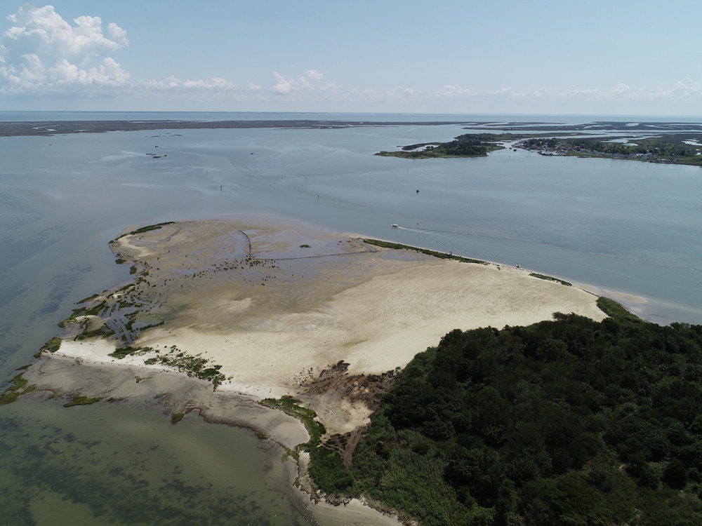
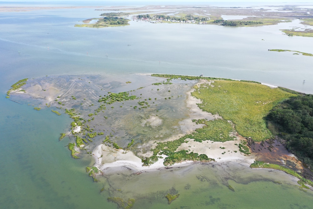
In October 2018, the Baltimore District of the U.S. Army Corps of Engineers began dredging the navigation channel that runs between Swan and Smith Islands in Chesapeake Bay. Approximately 60,000 cubic yards of the dredged sediments were used to restore the footprint of Swan Island. The restoration plan included creation of low dunes and high and low intertidal marsh. The island was transformed from one characterized by low and highly fragmented marsh to one with a wider range of habitats that sit higher in the tidal frame (Figure 1. Figure 2. Swan Island post placement 2019.jpg Figure 3. Swan Island 2020.jpg,).

Monitoring and Adaptive Management
The Swan Island restoration presents an opportunity to evaluate the efficacy of managing coastal islands to protect and enhance their long-term resilience to storms and sea level rise. Project success is being measured through the collaborative efforts of a multi-disciplinary project team with members from USACEs Engineer Research and Development Center (ERDC), USACE Baltimore District, NOAA National Centers for Coastal Ocean Science (NCCOS), US Fish and Wildlife Service and the Maryland Department of Natural Resources. Initially, the project team came together in a series of iterative group-mediated workshops to develop project goals and a conceptual model describing interactions between the island’s physical properties and biological communities. The outcome was a refining of the team’s project goals, a conceptual model (Figure 3), a monitoring program, and the development of a Monitoring and Adaptive Management Plan.
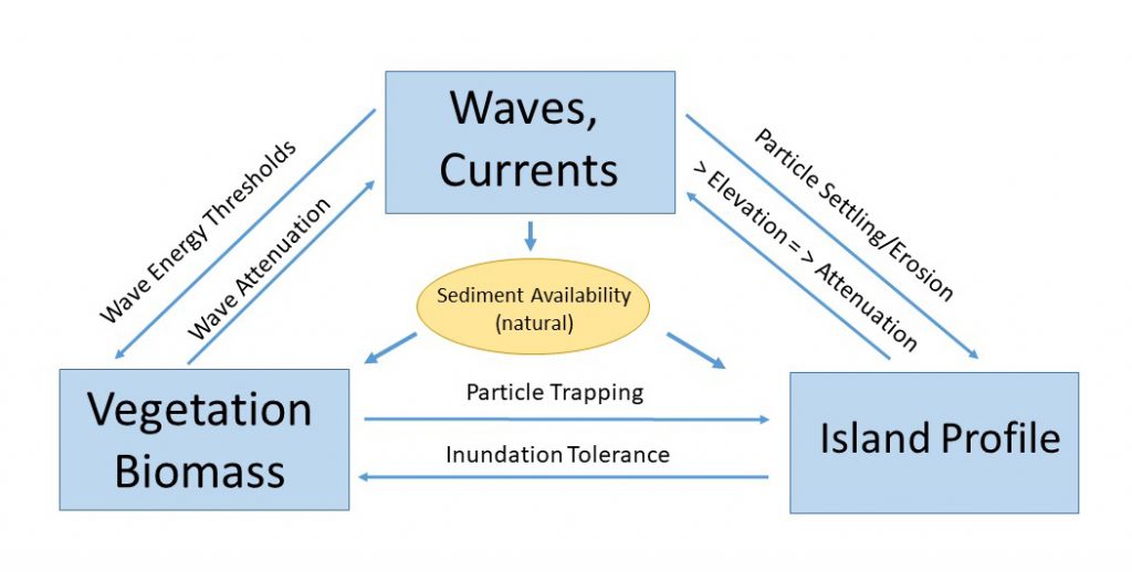
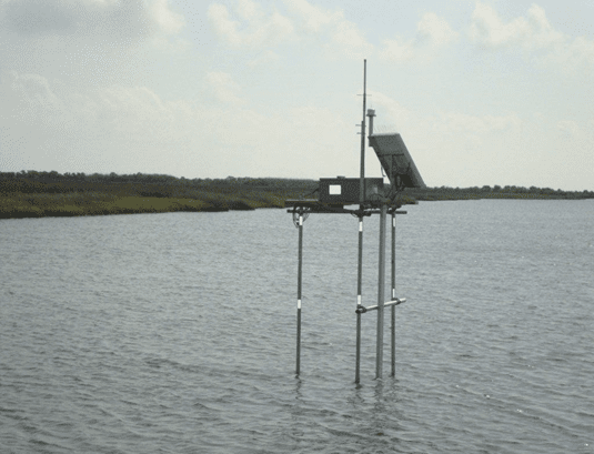
The overarching project goal is to quantify coastal resilience performance of Swan Island in terms of reducing wave energy and erosion to nearby shorelines and habitats. Researchers are collecting pre and post-restoration data such as sediment (total suspended solids, accretion), hydrodynamic (waves, currents, water level), ecological (vegetation) and topographic (elevations) parameters. These data will be used to develop and evaluate integrated hydrodynamic and ecological models that will answer questions such as: How resilient is the island and its habitats against rising sea level and periodic storm events? Or how much wave attenuation does Swan Island provide the Town of Ewell?
The Monitoring and Adaptive Management Plan (MAMP) tracks progress and serves as a blueprint for the project team for all aspects of the monitoring (e.g. What, How, and How often data is collected) and the adaptive management approach. This includes reporting, data management, roles and responsibilities, performance metrics and decision thresholds for adaptive management.
Study Results
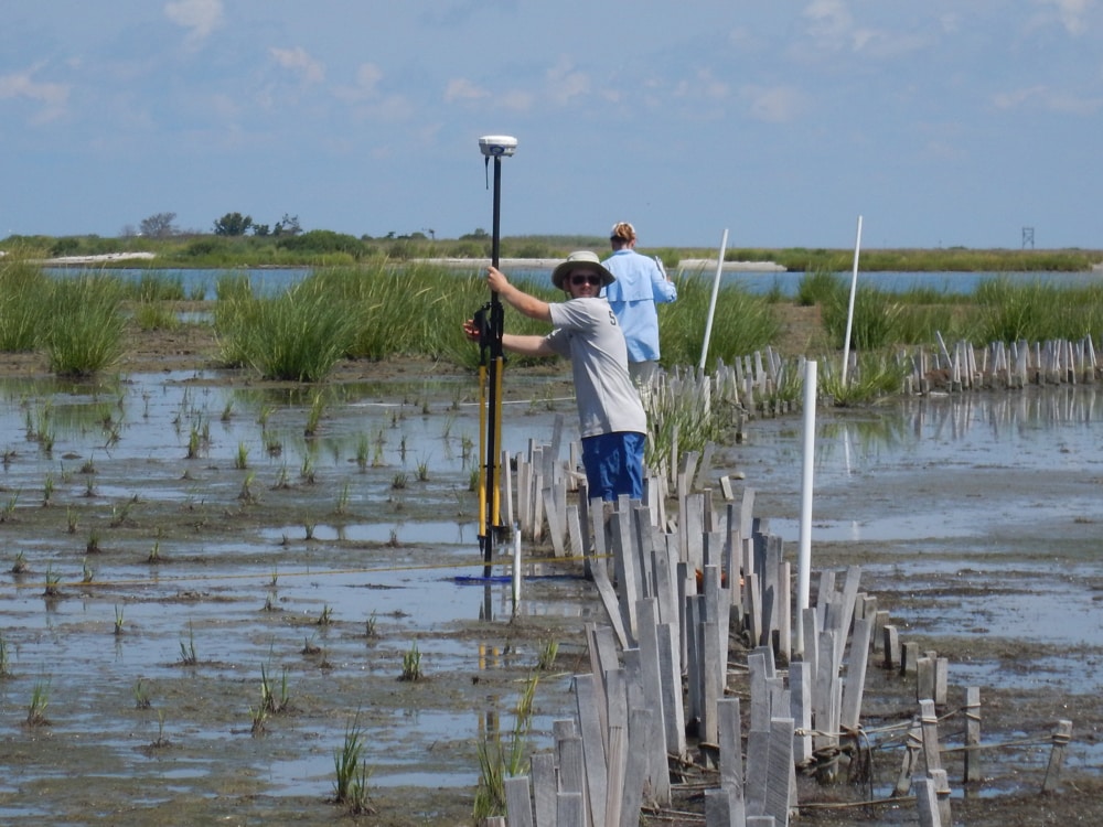
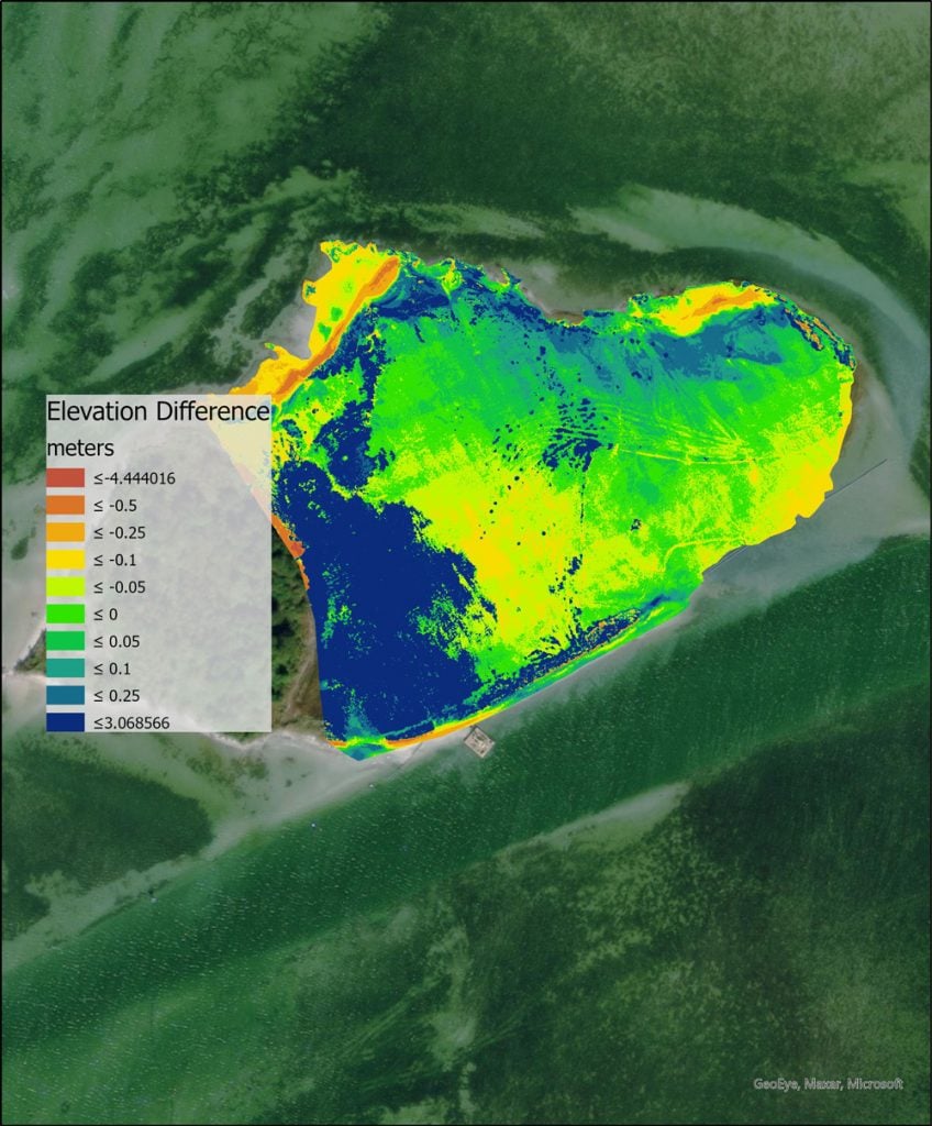
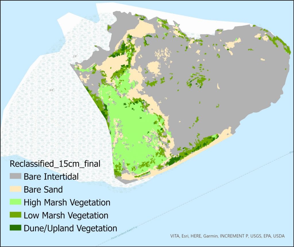
Two years of post-restoration monitoring has been completed. As of September 2020, the high marsh was characterized by vigorous ingrowth of planted Spartina patens with 50 percent cover in elevations from 0.5 – 0.9 meters NAVD88. However, below 0.4 meters NAVD the low marsh experienced significant mortality, triggering the adaptive management threshold for percent cover determined in the MAMP (Figure 3). Accordingly, the team intends to replant 25,000 low marsh (S. alterniflora) plants in Spring 2021. Shoreline erosion, elevation change, and trends in the aerial extent of the Island’s various vegetative communities are also being measured and tracked over time, using georeferenced drone-based imagery products such as Digital Elevation Models and habitat classification maps (Figure 7. Figure 8.). Trends in these data will be evaluated with respect to water movement (waves, tides and currents) through the model development process which is ongoing. Ultimately, the resulting simulation model will be used to quantify the relationships between physical and ecological changes in Swan Island and the impact of these changes on its long-term resilience.
Project Significance
The products developed through this project will inform the design and placement of future island restoration activities and will be used by regulatory agencies involved in permitting island restoration projects. Monitoring data collected for this project is being used to develop and evaluate an integrated hydrodynamic and ecological model to address how the island and its ecological communities will respond to physical forcings, like storms and sea level rise. The results of these modeling efforts will also address current information gaps on the impacts of island restoration activities on nearby ecosystems, and the protective benefits provided by these islands. The results will inform how restoring these islands, by leveraging natural and engineered processes, can achieve EWN ‘triple win’ benefits to address the uncertainties identified as barriers to implementation.
References
Erwin ME, Brinker DF, Watts BD, Costanzo GR, Morton DD. 2011. Islands at bay: rising seas, eroding islands, and waterbird habitat loss in Chesapeake Bay (USA). J Coast Conserv doi: 10.1007/s11852-010-0119-y.
Grant WE, Swannack TM 2008 Ecological Modeling: A Common-Sense Approach to Theory and Practice. Blackwell Publishing, Oxford UK. 155 Pp.
Herman B, Swannack TM, King JK, Whitfield PE, Davis J, Szimanski D, Bryant D, Gailani, J, (2020) Proceedings from the US Army Corps of Engineers and the National Oceanic and Atmospheric Administration – National Ocean Service, Ecological Modeling Workshop. April 11-12, 2019
Kearney MS, Stevenson JT, (1991) Island Land Loss and Marsh Vertical Accretion Rate Evidence for Historical Sea-Level Changes in Chesapeake Bay. J. Coastal Research. 7(2):403-415pp
Perini Management Services. 2014. Study Report, Smith Island, Martin National Wildlife Refuge, Hurricane Sandy Resiliency Project #31, Fog Point Living Shoreline Restoration.
Whitfield, Davis, Tritinger et al. (forthcoming) Draft Monitoring and Adaptive Management Plan for Swan Island, to be published as an ERDC Technical Report